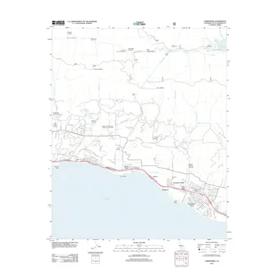
2012 Map of Carpinteria
USGS Topo · Published 2012About this map
Ortega Hill and the adjacent Santa Barbara Polo Grounds anchor this coastal landscape where the Santa Ynez Mountains meet the Pacific Ocean. This 2012 edition documents the complex water infrastructure essential to the region, featuring the Doulton Tunnel and its North Portal and South Portal, which convey water through the mountain range. Moving inland, the survey shows the educational and religious presence of Immaculate Heart College and the College of the Queen of Peace Jesuit Novitiate nestled in the foothills. Along the shoreline, residential enclaves like Sandyland Cove and Franciscan Village sit near the traditional center of Old Town. The northern portion of the map is dominated by the wilder terrain of the Los Padres National Forest, including Jameson Lake and the Blue Canyon Pass, highlighting the sharp transition from manicured polo fields to steep mountain canyons.
Find a feature on this map
107 named features on this map. Tap any name to fly to it.
Don’t see what you’re looking for? This feature index may not catch every label — zoom into the map to look around manually.
Map Details
Editions of this 2012 Carpinteria Map
This is the sole edition of this map. No revisions or reprints were ever made.
Other maps of this area

1902 · Santa Ynez
USGS Topo · 1:125,000

1903 · Mt. Pinos
USGS Topo · 1:125,000

1904 · Ventura
USGS Topo · 1:62,500

1905 · Santa Ynez
USGS Topo · 1:125,000

1941 · Ventura
USGS Topo · 1:62,500

1942 · Little Pine Mountain
USGS Topo · 1:24,000

1943 · Old Man Mountain
USGS Topo · 1:24,000

1943 · Hildreth Peak
USGS Topo · 1:24,000

1944 · Santa Barbara
USGS Topo · 1:31,680
1944 · Carpinteria
USGS Topo · 1:31,680