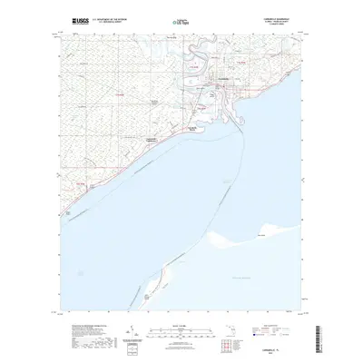
2021 Map of Carrabelle
USGS Topo · Published 2021About this map
Carrabelle sits at the confluence of several vital Florida Panhandle waterways, where the New River, Crooked River, and Carrabelle River meet before emptying into the Saint George Sound. This coastal geography is defined by complex wetland systems like Tates Hell Swamp and significant barrier islands, including Dog Island and the northern tip of Saint George Island. The presence of the Florida Circumnavigational Paddling Trl underscores the region's enduring connection to the water, while the Carrabelle Lighthouse and the Tillie Miller Bridge serve as essential navigational and transit landmarks. The map also reveals the inland character of Franklin County, from the elevated reaches of Warrens Bluff to the specialized landings and ponds such as Teal Miller Flats and McKissack Ponds, documenting a landscape where maritime access and tidal marshes dictate the patterns of human settlement and infrastructure.
Find a feature on this map
64 named features on this map. Tap any name to fly to it.
Don’t see what you’re looking for? This feature index may not catch every label — zoom into the map to look around manually.
Map Details
Editions of this 2021 Carrabelle Map
This is the sole edition of this map. No revisions or reprints were ever made.
Other maps of this area

1943 · Dog Island
USGS Topo · 1:31,680

1943 · Carrabelle
USGS Topo · 1:24,000

1944 · Pickett Bay
USGS Topo · 1:31,680

1944 · Carrabelle
USGS Topo · 1:31,680

1944 · Green Point
USGS Topo · 1:31,680

1944 · Sugar Hill
USGS Topo · 1:31,680

1945 · Tates Hell Swamp
USGS Topo · 1:31,680

1945 · Mc Intyre
USGS Topo · 1:31,680

1945 · Sugar Hill
USGS Topo · 1:31,680

1945 · Pickett Bay
USGS Topo · 1:31,680