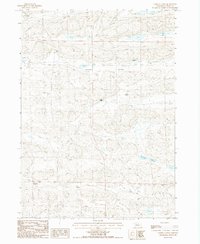
1987 Map of Carrico Lakes
USGS Topo · Published 1987About this map
Survey Valley dominates the northern reaches of this mid-1980s Nebraska Sandhills landscape, where the shifting topography creates a complex network of seasonal basins and small water bodies. The terrain is defined by its intermittent hydrology, including Carrico Lakes and numerous scattered wetlands labeled by their water levels, such as WL 3632 and WL 3652. Settlement is sparse and tied to the ranching economy of Cherry County, with family-named operations like the W Marshall Ranch, L Hoyt Ranch, and H Hoyt Ranch serving as the primary landmarks. This provisional survey captures the region as it appeared before many modern developments, showing a landscape of unimproved roads and remote trails through the dunes. It is an essential document for understanding the land-use patterns and family ranching heritage of this specific corner of the Nebraska interior.
Find a feature on this map
17 named features on this map. Tap any name to fly to it.
Don’t see what you’re looking for? This feature index may not catch every label — zoom into the map to look around manually.
Map Details
Editions of this 1987 Carrico Lakes Map
This is the sole edition of this map. No revisions or reprints were ever made.
Other maps of this area

1948 · Ashby
USGS Topo · 1:62,500

1948 · Whitman
USGS Topo · 1:62,500

1949 · Ashby
USGS Topo · 1:62,500

1949 · Steverson Lake
USGS Topo · 1:62,500

1949 · Turpin Lake
USGS Topo · 1:62,500

1950 · Whitman
USGS Topo · 1:62,500

1951 · Steverson Lake
USGS Topo · 1:62,500

1951 · Turpin Lake
USGS Topo · 1:62,500

1957 · Valentine
USGS Topo · 1:250,000

1959 · Valentine
USGS Topo · 1:250,000