
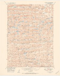
1951 Map of Steverson Lake
USGS Topo · Published 1951About this map
Arkansas Valley and the surrounding Sandhills of Cherry County are defined by a unique mosaic of ranching outposts and shallow lakes. This mid-century survey illustrates a landscape where water and family heritage dictated settlement, with prominent holdings such as Knudsen Ranch, Metzger Ranch, and Carver Ranch scattered across the Enlow terrain. The mapping reveals a sparse but organized community structure, supported by a network of rural schoolhouses including North School No 135 and School No 151. The hydrology of the region is intricate, featuring numerous water bodies like Steverson Lake, Home Valley Lake, and Buffalo Lake, alongside the distinctive Flowing Well sites that provided vital water for livestock. Transportation was largely dictated by the natural corridors of Survey Valley and the Middle Prong, with a dedicated Landing Field serving this isolated interior.
Find a feature on this map
56 named features on this map. Tap any name to fly to it.
Don’t see what you’re looking for? This feature index may not catch every label — zoom into the map to look around manually.
Map Details
Editions of this 1951 Steverson Lake Map
2 editions found
Other maps of this area

1948 · Ashby
USGS Topo · 1:62,500

1948 · Whitman
USGS Topo · 1:62,500

1949 · Ashby
USGS Topo · 1:62,500

1949 · Steverson Lake
USGS Topo · 1:62,500

1949 · Turpin Lake
USGS Topo · 1:62,500

1950 · Whitman
USGS Topo · 1:62,500

1950 · Hire
USGS Topo · 1:62,500

1950 · Doughboy
USGS Topo · 1:62,500

1950 · Wolf Lake
USGS Topo · 1:62,500

1951 · Gypsy Valley
USGS Topo · 1:62,500