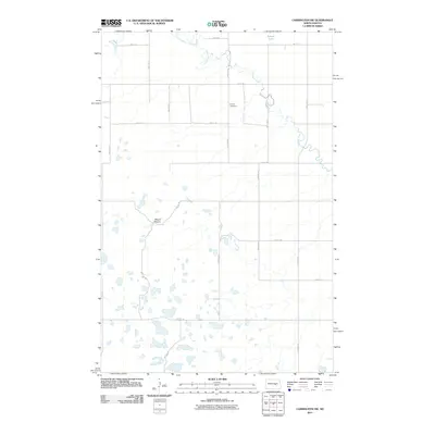
2011 Map of Carrington SW
USGS Topo · Published 2011About this map
Pipestem Creek winds through this section of Stutsman County, carving a narrow valley through a prairie landscape defined by glacial potholes and small wetlands. In the northern reaches, the creek is joined by Little Pipestem Creek near the shores of Russell Lake. The upland terrain is marked by isolated rises such as Mount Moriah, providing a rare point of elevation in an area otherwise dominated by a rigid grid of section-line roads including 5th St SE and 64th Ave SE. The presence of Calvary Cemetery north of the creek suggests the enduring community ties in this rural agricultural region. The map reveals the intricate drainage patterns of the high plains, where numerous small, unnamed sloughs and seasonal ponds scatter across the landscape between the larger watercourses.
Find a feature on this map
20 named features on this map. Tap any name to fly to it.
Don’t see what you’re looking for? This feature index may not catch every label — zoom into the map to look around manually.
Map Details
Editions of this 2011 Carrington SW Map
This is the sole edition of this map. No revisions or reprints were ever made.
Other maps of this area

1948 · Carrington
USGS Topo · 1:62,500

1950 · Carrington East
USGS Topo · 1:24,000

1950 · Melville
USGS Topo · 1:24,000

1950 · Carrington SW
USGS Topo · 1:24,000

1950 · Carrington West
USGS Topo · 1:24,000

1951 · Dover
USGS Topo · 1:24,000

1952 · New Rockford
USGS Topo · 1:250,000

1956 · New Rockford
USGS Topo · 1:250,000
1958 · Vashti
USGS Topo · 1:24,000

1958 · Goldwin
USGS Topo · 1:24,000