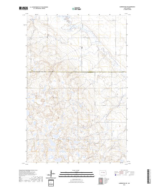
2024 Map of Carrington SW
USGS Topo · Published 2024About this map
The Stutsman County Waterfowl Production Area occupies a central portion of this landscape, reflecting a region defined by prairie potholes and wetland conservation. This northern plains terrain, straddling the boundary between Foster and Stutsman counties, is characterized by its rolling topography and numerous small, unnamed water bodies. Family and local history is preserved at the Pleasant Valley Adventist Cem and Calvary Cem, which serve as quiet landmarks along the rural grid of section roads. The hydrology is dominated by the meandering paths of Pipestem Creek and its tributary, Little Pipestem Creek, while Mount Morian provides a localized high point. The map illustrates a strictly agricultural and conservation-focused layout, where the geometric precision of township and range lines meets the irregular, water-carved features of the North Dakota prairie.
Find a feature on this map
29 named features on this map. Tap any name to fly to it.
Don’t see what you’re looking for? This feature index may not catch every label — zoom into the map to look around manually.
Map Details
Editions of this 2024 Carrington SW Map
This is the sole edition of this map. No revisions or reprints were ever made.
Other maps of this area

1948 · Carrington
USGS Topo · 1:62,500

1950 · Carrington East
USGS Topo · 1:24,000

1950 · Melville
USGS Topo · 1:24,000

1950 · Carrington SW
USGS Topo · 1:24,000

1950 · Carrington West
USGS Topo · 1:24,000

1951 · Dover
USGS Topo · 1:24,000

1952 · New Rockford
USGS Topo · 1:250,000

1956 · New Rockford
USGS Topo · 1:250,000
1958 · Vashti
USGS Topo · 1:24,000

1958 · Goldwin
USGS Topo · 1:24,000