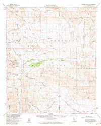
1959 Map of Carrizo Mountain
USGS Topo · Published 1964About this map
Anza-Borrego Desert State Park occupies a significant portion of this late 1950s survey, revealing a landscape defined by seasonal washes and historic desert transit. The Old Overland Stage Route cuts through the terrain, passing the Old Carrizo Stage Sta, a key reminder of the stagecoach era's reliance on reliable water sources like Carrizo Creek. In the southwest, the San Diego and Arizona Eastern Railroad snakes through the Jacumba Mountains, its tunnels and tracks skirting the Volcanic Hills. This era of documentation highlights the transition from early resource extraction to conservation, noting sites like the Dos Cabezas Mine and Montero Quarry alongside the protected groves of the Mountain Palm Springs Area, including Surprise Canyon Grove and Pygmy Grove.
Find a feature on this map
91 named features on this map. Tap any name to fly to it.
Don’t see what you’re looking for? This feature index may not catch every label — zoom into the map to look around manually.
Map Details
Editions of this 1959 Carrizo Mountain Map
2 editions found
Other maps of this area

1915 · El Centro
USGS Topo · 1:125,000

1931 · Vallecito
USGS Topo · 1:125,000

1931 · Carrizo
USGS Topo · 1:125,000

1939 · Campo
USGS Topo · 1:62,500

1939 · Borrego
USGS Topo · 1:62,500

1939 · Jacumba
USGS Topo · 1:62,500

1940 · Kane Spring
USGS Topo · 1:62,500

1940 · Plaster City
USGS Topo · 1:62,500

1940 · Coyote Wells
USGS Topo · 1:62,500

1942 · Barrel Spring
USGS Topo · 1:62,500