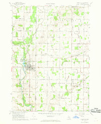
1967 Map of Carson City
USGS Topo · Published 1968About this map
Carson City serves as the industrial and social anchor of this mid-Michigan landscape in the late 1960s, notably featuring an Oil Refinery and a Condensery along the banks of Fish Creek. The map documents a rural transition where agricultural lands in North Shade and Bloomer townships are dotted with essential community markers like the North Shade Sch and the United Brethren Church Camp. An intricate network of drainage systems, including the North Shade Drain and Myra Drain, reveals the managed hydrology required to maintain the area's productive fields.
Find a feature on this map
66 named features on this map. Tap any name to fly to it.
Don’t see what you’re looking for? This feature index may not catch every label — zoom into the map to look around manually.
Map Details
Editions of this 1967 Carson City Map
This is the sole edition of this map. No revisions or reprints were ever made.
Other maps of this area

1918 · Perrinton
USGS Topo · 1:62,500

1935 · Alma
USGS Topo · 1:62,500

1938 · Alma
USGS Topo · 1:62,500

1943 · Perrinton
USGS Topo · 1:62,500

1954 · Midland
USGS Topo · 1:250,000

1958 · Midland
USGS Topo · 1:250,000

1959 · Midland
USGS Topo · 1:250,000

1965 · Sumner
USGS Topo · 1:24,000
1965 · Perrinton
USGS Topo · 1:24,000

1965 · Crystal
USGS Topo · 1:24,000