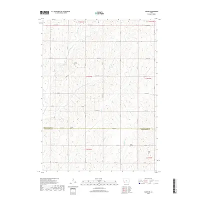
2018 Map of Carson NE
USGS Topo · Published 2018About this map
Wheeler Grove Cem and Pleasant Grove Cem sit within a landscape of deeply dissected loess hills in this rural corner of Southwest Iowa. The map documents the border between Pottawattamie and Montgomery counties, where a dense network of watercourses including Spring Cr, Jordan Cr, and Indian Cr have carved a complex topography of ridges and draws. This drainage pattern dictates the placement of roads like Pioneer Trl and Beechnut Rd, which often follow the natural contours of the land. For genealogists, the placement of the Center Ridge Cem and Elliot Hillside Cem provides vital spatial context for early settler families in these townships. The map reflects a modern agricultural era where traditional section-line roads like Cottonwood Rd and Applewood Rd intersect with the winding paths of Farm Cr and Little Indian Cr.
Find a feature on this map
27 named features on this map. Tap any name to fly to it.
Don’t see what you’re looking for? This feature index may not catch every label — zoom into the map to look around manually.
Map Details
Editions of this 2018 Carson NE Map
This is the sole edition of this map. No revisions or reprints were ever made.
Other maps of this area

1954 · Omaha
USGS Topo · 1:250,000

1957 · Omaha
USGS Topo · 1:250,000

1958 · Omaha
USGS Topo · 1:250,000

1963 · Avoca SE
USGS Topo · 1:24,000

1963 · Oakland
USGS Topo · 1:24,000

1971 · Atlantic SW
USGS Topo · 1:24,000

1978 · Carson
USGS Topo · 1:24,000

1978 · Griswold
USGS Topo · 1:24,000
1978 · Emerson
USGS Topo · 1:24,000

1978 · Wales
USGS Topo · 1:24,000