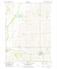
1978 Map of Emerson
USGS Topo · Published 1978About this map
The West Nishnabotna River flows through this southwestern Iowa landscape, where the agricultural community of Hastings sits near the confluence of Mud Creek and Indian Creek. In the late 1970s, this area of Mills and Montgomery counties was defined by its railroad connectivity and rural institutions. The Burlington Northern line cuts across the terrain, serving the town of Emerson and several industrial sites, including a Pumping Station and Water Tank along the central corridor.
Find a feature on this map
30 named features on this map. Tap any name to fly to it.
Don’t see what you’re looking for? This feature index may not catch every label — zoom into the map to look around manually.
Map Details
Editions of this 1978 Emerson Map
This is the sole edition of this map. No revisions or reprints were ever made.
Other maps of this area

1954 · Omaha
USGS Topo · 1:250,000

1955 · Nebraska City
USGS Topo · 1:250,000

1956 · Treynor
USGS Topo · 1:24,000

1956 · Malvern
USGS Topo · 1:24,000

1957 · Nebraska City
USGS Topo · 1:250,000

1957 · Omaha
USGS Topo · 1:250,000

1957 · Tabor NE
USGS Topo · 1:24,000

1958 · Omaha
USGS Topo · 1:250,000

1958 · Nebraska City
USGS Topo · 1:250,000

1978 · Carson
USGS Topo · 1:24,000