
1978 Map of Griswold
USGS Topo · Published 1978About this map
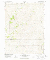
The East Nishnabotna River serves as the central geographic feature of this southwestern Iowa landscape, winding southward between the communities of Griswold and Elliott. This 1970s survey captures the region's agricultural and transit orientation, dominated by the Burlington Northern railroad corridor and a network of creeks like Baughmans Creek and Clarks Branch. For genealogists, the map is remarkably detailed, locating numerous local burial sites including Griswold Cem, Flint Cem, Township Cem, Mercer Cem, Waveland Cem, and Hillside Cem. The smaller settlement of Coe appears south of Elliott, while the presence of Gravel Pits and sewage infrastructure near the river points to the local industrial and municipal activity of the era. The terrain is further defined by the crossing of three county lines — Pottawattamie, Cass, and Montgomery — marking the administrative borders within the townships of Waveland, Pleasant, and Sherman.
Find a feature on this map
30 named features on this map. Tap any name to fly to it.
Don’t see what you’re looking for? This feature index may not catch every label — zoom into the map to look around manually.
Map Details
Editions of this 1978 Griswold Map
This is the sole edition of this map. No revisions or reprints were ever made.
Other maps of this area

1954 · Omaha
USGS Topo · 1:250,000

1957 · Omaha
USGS Topo · 1:250,000

1958 · Omaha
USGS Topo · 1:250,000

1963 · Avoca SE
USGS Topo · 1:24,000

1971 · Atlantic SW
USGS Topo · 1:24,000

1971 · Lewis
USGS Topo · 1:24,000

1978 · Wallin
USGS Topo · 1:24,000

1978 · Wales
USGS Topo · 1:24,000

1978 · Griswold NE
USGS Topo · 1:24,000
1978 · Carson NE
USGS Topo · 1:24,000