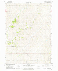
1978 Map of Carson NE
USGS Topo · Published 1978About this map
Indian Creek and Jordan Creek wind through this corner of Southwest Iowa, where the landscape is defined by the agricultural rhythms of Grove and Waveland townships. The map documents the boundary where Pottawattamie and Montgomery counties meet, revealing a rural infrastructure of scattered farmsteads and small country congregations. Local heritage is centered around sites like the Wheeler Grove Ch and Center Ridge Ch, alongside the Mormon Cem, which speaks to the historic migratory paths through the region. A specialized glimpse of late-twentieth-century rural life is visible in landmarks such as the Petersen Landing Strip and a Quarry located near Farm Creek. The drainage patterns of Graybill Creek and Crabapple Creek further illustrate the topographic character of this productive farming country.
Find a feature on this map
22 named features on this map. Tap any name to fly to it.
Don’t see what you’re looking for? This feature index may not catch every label — zoom into the map to look around manually.
Map Details
Editions of this 1978 Carson NE Map
This is the sole edition of this map. No revisions or reprints were ever made.
Other maps of this area

1954 · Omaha
USGS Topo · 1:250,000

1957 · Omaha
USGS Topo · 1:250,000

1958 · Omaha
USGS Topo · 1:250,000

1963 · Avoca SE
USGS Topo · 1:24,000

1963 · Oakland
USGS Topo · 1:24,000

1971 · Atlantic SW
USGS Topo · 1:24,000

1978 · Carson
USGS Topo · 1:24,000

1978 · Griswold
USGS Topo · 1:24,000
1978 · Emerson
USGS Topo · 1:24,000

1978 · Wales
USGS Topo · 1:24,000