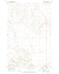
1970 Map of Carter NE
USGS Topo · Published 1974About this map
The Teton River cuts through the southern reaches of this Chouteau County landscape, creating a distinct riparian corridor contrasted against the higher benchlands. Based on 1969 aerial photography and field-checked in 1970, the map illustrates an intricate drainage system where the Bullberry Coulee and Chimney Rock Coulee feed into broader basins. These coulees, along with the Dry Fork Coulee and West Dry Fork Coulee, define the erosion patterns of the high plains, revealing the natural routes used for travel and ranching before modern development. Smaller landmarks like the Frank Gilbert Coulee and Oder Coulee provide specific points of reference for local historians, while a Gravel Pit near the river indicates the early extractive needs of the region's road network.
Find a feature on this map
8 named features on this map. Tap any name to fly to it.
Don’t see what you’re looking for? This feature index may not catch every label — zoom into the map to look around manually.
Map Details
Editions of this 1970 Carter NE Map
This is the sole edition of this map. No revisions or reprints were ever made.
Other maps of this area

1890 · Fort Benton
USGS Topo · 1:250,000

1892 · Fort Benton
USGS Topo · 1:250,000

1897 · Fort Benton
USGS Topo · 1:250,000

1953 · Carter
USGS Topo · 1:24,000

1953 · Tunis
USGS Topo · 1:24,000

1954 · Great Falls
USGS Topo · 1:250,000

1954 · Fort Benton
USGS Topo · 1:24,000

1954 · Shelby
USGS Topo · 1:250,000

1957 · Great Falls
USGS Topo · 1:250,000

1958 · Shelby
USGS Topo · 1:250,000