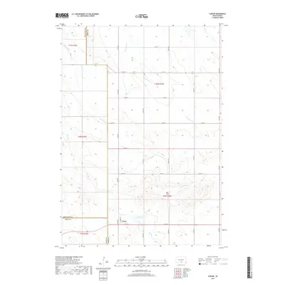
2017 Map of Carter
USGS Topo · Published 2017About this map
Carter serves as the primary settlement on this South Dakota landscape, situated at the junction of Filmore St and 277th St. The terrain is defined by the prominent Red Hills, where the elevation rises significantly above the surrounding plains. Water management is a central feature of the local geography, notably the Carter Dam Reservoir south of the town center. The map reveals a highly structured section-line road network typical of the Great Plains, where routes like 302nd Ave and 270th St provide access across the rolling topography. Several drainage systems, including Two Nation Cr, McChesneys Cr, and De Bell Cr, create natural breaks in the grid, illustrating the relationship between the prairie hydrology and the rural infrastructure at the meeting of Tripp Co, Mellette Co, and Todd Co.
Find a feature on this map
27 named features on this map. Tap any name to fly to it.
Don’t see what you’re looking for? This feature index may not catch every label — zoom into the map to look around manually.
Map Details
Editions of this 2017 Carter Map
This is the sole edition of this map. No revisions or reprints were ever made.
Other maps of this area

1955 · Martin
USGS Topo · 1:250,000

1958 · Martin
USGS Topo · 1:250,000

1982 · Presho 4 SE
USGS Topo · 1:25,000

1982 · Witten SE
USGS Topo · 1:25,000

1982 · Two Nation Creek
USGS Topo · 1:25,000

1982 · Badnation SE
USGS Topo · 1:25,000

1982 · Witten
USGS Topo · 1:25,000

1982 · Witten SW
USGS Topo · 1:25,000

1982 · Okreek SE
USGS Topo · 1:24,000
1982 · Carter
USGS Topo · 1:25,000