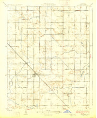
1925 Map of Caruthers
USGS Topo · Published 1925About this map
Caruthers serves as the central hub of this agricultural landscape in Fresno County, anchored by the diagonal line of the Southern Pacific railroad. The 1920s topography reveals a meticulously planned grid of rural avenues named for families and local landmarks, suggesting a period of intense land subdivision and irrigation-driven growth. Educational life is highly visible through a network of rural schoolhouses, including the Nipponese School, Alvina School, and Princeton School, reflecting the diverse community of early 20th-century settlers. Water management is critical to this valley environment, evidenced by infrastructure like the South Ditch and various nameless canals that parallel the road network. Smaller settlements like Bowles and the University Colony complement the primary townsite, providing a clear view of the settlement patterns established before the mid-century expansion of California's Central Valley.
Find a feature on this map
43 named features on this map. Tap any name to fly to it.
Don’t see what you’re looking for? This feature index may not catch every label — zoom into the map to look around manually.
Map Details
Editions of this 1925 Caruthers Map
2 editions found
Other maps of this area

1923 · Kearney Park
USGS Topo · 1:31,680

1923 · Malaga
USGS Topo · 1:31,680

1923 · Fresno
USGS Topo · 1:31,680

1924 · Riverdale
USGS Topo · 1:31,680

1924 · Conejo
USGS Topo · 1:31,680

1925 · Raisin
USGS Topo · 1:31,680

1925 · Caruthers
USGS Topo · 1:31,680

1927 · Laton
USGS Topo · 1:31,680

1927 · Burrel
USGS Topo · 1:31,680

1927 · Riverdale
USGS Topo · 1:31,680