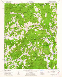
1960 Map of Carvers Gap
USGS Topo · Published 1962About this map
The high ridges of the Cherokee National Forest and Pisgah National Forest meet along the state line in this 1960s study, where the Appalachian Trail traverses the lofty peaks of Roan High Knob and Round Bald. The landscape is defined by its extreme elevation changes, dropping from the open balds down into the deep valleys of Roaring Creek and the North Toe River. Small communities and family enclaves are tucked along the watercourses, marked by local institutions like the Glen Ayre Sch and Cane Creek Ch.
Find a feature on this map
136 named features on this map. Tap any name to fly to it.
Don’t see what you’re looking for? This feature index may not catch every label — zoom into the map to look around manually.
Map Details
Editions of this 1960 Carvers Gap Map
2 editions found
Other maps of this area

1891 · Roan Mountain
USGS Topo · 1:125,000

1893 · Cranberry
USGS Topo · 1:125,000

1894 · Roan Mountain
USGS Topo · 1:125,000

1895 · Cranberry
USGS Topo · 1:125,000

1899 · Cranberry
USGS Topo · 1:125,000

1900 · Mount Mitchell
USGS Topo · 1:125,000

1902 · Cranberry
USGS Topo · 1:125,000

1902 · Mount Mitchell
USGS Topo · 1:125,000

1904 · Roan Mountain
USGS Topo · 1:125,000

1905 · Morganton
USGS Topo · 1:125,000