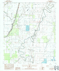
1988 Map of Cary
USGS Topo · Published 1988About this map
The winding waters of Deer Creek and Steele Bayou define this landscape in the Mississippi Delta, where the relationship between the alluvial terrain and modern agriculture is clearly documented. The small settlement of Cary serves as a central hub, flanked by the smaller community of Egremont to the north and Issaquena to the south. This 1988 provisional edition highlights the conversion of the landscape, noting several large Fish Farm operations characterized by structured rectangular ponds, a stark contrast to the irregular meandering of natural waterways like Newsom Bayou and Coon Bayou.
Find a feature on this map
18 named features on this map. Tap any name to fly to it.
Don’t see what you’re looking for? This feature index may not catch every label — zoom into the map to look around manually.
Map Details
Editions of this 1988 Cary Map
This is the sole edition of this map. No revisions or reprints were ever made.
Other maps of this area

1909 · Wilsons Point
USGS Topo · 1:24,000

1913 · Wilson Point
USGS Topo · 1:31,680

1939 · Onward
USGS Topo · 1:62,500

1939 · Lorenzen
USGS Topo · 1:62,500

1939 · Alsatia
USGS Topo · 1:62,500

1939 · Mayersville
USGS Topo · 1:62,500

1955 · Jackson
USGS Topo · 1:250,000

1961 · Jackson
USGS Topo · 1:250,000

1962 · Jackson
USGS Topo · 1:250,000

1963 · Onward
USGS Topo · 1:62,500