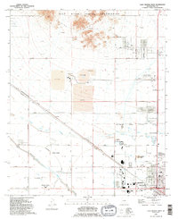
1992 Map of Casa Grande West
USGS Topo · Published 1992About this map
The Sacaton Mountains rise sharply in the northern portion of this quadrangle, looking down upon the industrial and agricultural landscape that defines the outskirts of Casa Grande. Evidence of the region’s mineral wealth is prominent near the center of the sheet, marked by an Open Pit Mine surrounded by extensive Mine Tailings and multiple Mine Dump sites. These heavy industrial operations sit in contrast to the growing residential and recreational developments to the south, including the Francisco Grande area and its Golf Course.
Find a feature on this map
35 named features on this map. Tap any name to fly to it.
Don’t see what you’re looking for? This feature index may not catch every label — zoom into the map to look around manually.
Map Details
Editions of this 1992 Casa Grande West Map
This is the sole edition of this map. No revisions or reprints were ever made.
Other maps of this area

1907 · Sacaton
USGS Topo · 1:62,500

1914 · Gila Butte
USGS Topo · 1:62,500

1917 · Gila Butte
USGS Topo · 1:62,500

1922 · Casa Grande
USGS Topo · 1:62,500

1922 · Signal Peak
USGS Topo · 1:62,500

1924 · Signal Peak
USGS Topo · 1:62,500

1924 · Casa Grande
USGS Topo · 1:62,500

1952 · Gila Butte SE
USGS Topo · 1:24,000

1952 · Sacaton Butte
USGS Topo · 1:24,000

1952 · Gila Butte
USGS Topo · 1:62,500