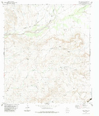
1983 Map of Casa Piedra
USGS Topo · Published 1983About this map
Casa Piedra sits at the junction of rail and water in this arid West Texas landscape, where the Atchison Topeka and Santa Fe railroad follows the winding course of Alamito Creek. The map documents a transition in local ranching and transportation, evidenced by the presence of a small Cem near the tracks and remote outposts like Holguin Camp. Water sources are the defining lifeline of the terrain, with several Flowing Wells, the White Spring, and numerous named windmills such as the Loma Alta Windmill scattered across the draws and canyons. The geography is deeply dissected by drainages like Trasquila Canyon and Holguin Canyon, while Pulpito and the Black Hills provide prominent vertical relief. Aviation plays a clear role in this isolated region, as seen by the designated Landing Strips and the specific Holguin Landing Strip near the head of its namesake creek.
Find a feature on this map
28 named features on this map. Tap any name to fly to it.
Don’t see what you’re looking for? This feature index may not catch every label — zoom into the map to look around manually.
Map Details
Editions of this 1983 Casa Piedra Map
This is the sole edition of this map. No revisions or reprints were ever made.
Other maps of this area

1896 · Shafter
USGS Topo · 1:125,000

1917 · Tascotal Mesa
USGS Topo · 1:62,500

1918 · Jordan Gap
USGS Topo · 1:62,500

1930 · Jordan Gap
USGS Topo · 1:62,500

1944 · Tascotal Mesa
USGS Topo · 1:62,500

1959 · Emory Peak
USGS Topo · 1:250,000

1959 · Presidio
USGS Topo · 1:250,000

1965 · Presidio
USGS Topo · 1:250,000

1965 · Emory Peak
USGS Topo · 1:250,000

1983 · Plata
USGS Topo · 1:24,000