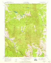
1948 Map of Cascade
USGS Topo · Published 1959About this map
The Rampart Range dominates this landscape, where the steep canyons and ridges of the Pike National Forest meet the early 20th-century settlements of El Paso County. Along the valley floor, the Midland Terminal Railroad (Abandoned) traces a path through Cascade and Chipita Park, following the course of Fountain Creek. A notable institutional presence is found at the Modern Woodmen of America Sanatorium near Woodmen, reflecting the era's regional focus on health and mountain convalescence.
Find a feature on this map
44 named features on this map. Tap any name to fly to it.
Don’t see what you’re looking for? This feature index may not catch every label — zoom into the map to look around manually.
Map Details
Editions of this 1948 Cascade Map
2 editions found

Other maps of this area

1893 · Platte Canyon
USGS Topo · 1:125,000

1893 · Colorado Springs
USGS Topo · 1:125,000

1894 · Pikes Peak
USGS Topo · 1:125,000

1894 · Castle Rock
USGS Topo · 1:125,000

1901 · Pikes Peak
USGS Topo · 1:125,000

1901 · Pikes Peak
USGS Topo · 1:62,500

1909 · Colorado Springs
USGS Topo · 1:125,000

1913 · Castle Rock
USGS Topo · 1:125,000

1942 · Colorado Springs
USGS Topo · 1:125,000

1948 · Manitou Springs
USGS Topo · 1:24,000