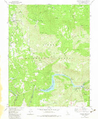
1982 Map of Cascadel Point
USGS Topo · Published 1983About this map
The San Joaquin River carves through this portion of the Sierra National Forest, marking the boundary between Madera and Fresno counties. This early 1980s landscape is defined by its hydroelectric infrastructure, with a series of facilities including Powerhouse 2, Powerhouse 3, and Powerhouse 4 connected by an aqueduct and surge chambers. The impounded waters of Redinger Lake dominate the canyon floor, providing a recreational focal point with its boat ramp and access via the winding Italian Bar Road.
Find a feature on this map
49 named features on this map. Tap any name to fly to it.
Don’t see what you’re looking for? This feature index may not catch every label — zoom into the map to look around manually.
Map Details
Editions of this 1982 Cascadel Point Map
This is the sole edition of this map. No revisions or reprints were ever made.
Other maps of this area

1904 · Kaiser
USGS Topo · 1:125,000

1912 · Mariposa
USGS Topo · 1:125,000

1942 · Millerton Lake
USGS Topo · 1:62,500

1945 · Millerton Lake
USGS Topo · 1:62,500

1947 · Mariposa
USGS Topo · 1:250,000

1948 · Mariposa
USGS Topo · 1:250,000
1953 · Bass Lake
USGS Topo · 1:62,500

1953 · Shaver Lake
USGS Topo · 1:62,500

1953 · Shuteye Peak
USGS Topo · 1:62,500

1957 · Mariposa
USGS Topo · 1:250,000