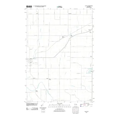
2010 Map of Casco
USGS Topo · Published 2010About this map
The Kewaunee River and its various tributaries define the rural character of this Kewaunee County landscape at the beginning of the 21st century. The village of Casco serves as a central hub, where the Casco Millpond indicates a history tied to water management and milling. Small unincorporated communities and rural clusters like Slovan, Clyde, and Rio Creek are scattered throughout the quadrangle, connected by a dense grid of county highways and local roads such as County Hwy-C and Rockledge Rd.
Find a feature on this map
71 named features on this map. Tap any name to fly to it.
Don’t see what you’re looking for? This feature index may not catch every label — zoom into the map to look around manually.
Map Details
Editions of this 2010 Casco Map
This is the sole edition of this map. No revisions or reprints were ever made.
Other maps of this area

1952 · Casco
USGS Topo · 1:62,500

1954 · Kewaunee
USGS Topo · 1:62,500

1954 · Manitowoc
USGS Topo · 1:250,000

1958 · Manitowoc
USGS Topo · 1:250,000

1960 · Algoma
USGS Topo · 1:62,500

1978 · Casco
USGS Topo · 1:24,000

1978 · Namur
USGS Topo · 1:24,000

1978 · Stangelville
USGS Topo · 1:24,000
1978 · Luxemburg
USGS Topo · 1:24,000

1978 · Brussels
USGS Topo · 1:24,000