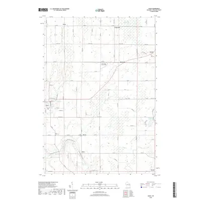
2018 Map of Casco
USGS Topo · Published 2018About this map
The Casco Millpond and the upper reaches of the Kewaunee River anchor this rural landscape in Kewaunee County. Small, established settlements including Casco, Slovan, and Rio Creek are connected by a dense grid of farm-to-market roads, such as Irish Rd and Pheasant Rd. This area is particularly dense with genealogical markers, featuring several community burial grounds including Holy Trinity Cem and Saint Adalberts Cem. The terrain is shaped by the Black Ash Swamp to the north and the winding paths of Casco Cr and Mashek Cr. Unusual for such a rural agricultural district is the Walter's Agri-Center Airport, reflecting the intersection of modern aviation and traditional farming. To the east, the village of Rankin sits near Saint Johns Cem, while West Alaska Lake provides a natural landmark amidst the surveyed sections.
Find a feature on this map
83 named features on this map. Tap any name to fly to it.
Don’t see what you’re looking for? This feature index may not catch every label — zoom into the map to look around manually.
Map Details
Editions of this 2018 Casco Map
This is the sole edition of this map. No revisions or reprints were ever made.
Other maps of this area

1952 · Casco
USGS Topo · 1:62,500

1954 · Kewaunee
USGS Topo · 1:62,500

1954 · Manitowoc
USGS Topo · 1:250,000

1958 · Manitowoc
USGS Topo · 1:250,000

1960 · Algoma
USGS Topo · 1:62,500

1978 · Casco
USGS Topo · 1:24,000

1978 · Namur
USGS Topo · 1:24,000

1978 · Stangelville
USGS Topo · 1:24,000
1978 · Luxemburg
USGS Topo · 1:24,000

1978 · Brussels
USGS Topo · 1:24,000