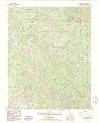
1987 Map of Case Mountain
USGS Topo · Published 1987About this map
Sequoia National Park dominates this landscape in the southern Sierra Nevada, where the intricate drainage system of the Kaweah River shapes the steep topography. The map illustrates the gateway to the high country at the Ash Mountain National Park Headquarters, serving as a primary administrative hub for the region. Small clusters of human activity are concentrated along the riverbanks, including the settlement at Hammond and the small outpost of Oak Grove, representing the transition from valley foothills to alpine wilderness.
Find a feature on this map
29 named features on this map. Tap any name to fly to it.
Don’t see what you’re looking for? This feature index may not catch every label — zoom into the map to look around manually.
Map Details
Editions of this 1987 Case Mountain Map
2 editions found
Other maps of this area

1903 · Tehipite
USGS Topo · 1:125,000

1904 · Kaweah
USGS Topo · 1:125,000

1905 · Tehipite
USGS Topo · 1:125,000

1909 · Kaweah
USGS Topo · 1:125,000

1937 · Kaweah
USGS Topo · 1:125,000

1948 · Fresno
USGS Topo · 1:250,000

1955 · Fresno
USGS Topo · 1:250,000

1956 · Fresno
USGS Topo · 1:250,000

1956 · Giant Forest
USGS Topo · 1:62,500

1956 · Mineral King
USGS Topo · 1:62,500