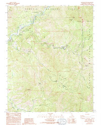
1987 Map of Case Mountain
USGS Topo · Published 1994About this map
Sequoia National Park dominates this landscape, where the confluence of several river forks defines the local topography and historical accessibility. The Ash Mountain National Park Headquarters serves as a primary hub near the Kaweah River, while small communities like Hammond and Oak Grove dot the lower elevations. The terrain is marked by significant vertical relief, rising from the river valleys to Case Mountain and the Case Mountain (Sierra Redwoods) Grove. This 1980s survey captures a transition from managed park services to wilderness, with features such as the Lookout Point Ranger Station and a remote Prospect mine providing clues to the era's fire management and land use. Waterways like Salt Creek and Grunigen Creek carve through the high country, leading toward high-altitude outposts such as Milk Ranch and the community of Paradise along Paradise Ridge.
Find a feature on this map
32 named features on this map. Tap any name to fly to it.
Don’t see what you’re looking for? This feature index may not catch every label — zoom into the map to look around manually.
Map Details
Editions of this 1987 Case Mountain Map
2 editions found
Other maps of this area

1903 · Tehipite
USGS Topo · 1:125,000

1904 · Kaweah
USGS Topo · 1:125,000

1905 · Tehipite
USGS Topo · 1:125,000

1909 · Kaweah
USGS Topo · 1:125,000

1937 · Kaweah
USGS Topo · 1:125,000

1948 · Fresno
USGS Topo · 1:250,000

1955 · Fresno
USGS Topo · 1:250,000

1956 · Fresno
USGS Topo · 1:250,000

1956 · Giant Forest
USGS Topo · 1:62,500

1956 · Mineral King
USGS Topo · 1:62,500