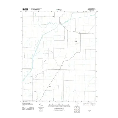
2011 Map of Cash
USGS Topo · Published 2011About this map
The Cache River and its complex network of managed waterways, including West Cache River Slough and Gunner Slough, define this corner of Craighead County. In the early 21st century, this agricultural landscape is organized around small settlements and crossroads like Cash, Egypt, and Dryden. The region's reliance on drainage and water management is evident in the numerous named channels such as Farley Ditch, Angle Ditch Lateral Number 4, and Ditch Number 32, which segment the flat delta terrain. For local historians and genealogists, the Johnson Cemetery stands as a notable landmark near Fisher, while the cluster of Three Way and Winesburg suggests established community centers. The map also documents physical crossings like Logan Bridge and the low-lying Jimmy Ridge, providing a clear record of the rural infrastructure and land use in this part of northeastern Arkansas.
Find a feature on this map
66 named features on this map. Tap any name to fly to it.
Don’t see what you’re looking for? This feature index may not catch every label — zoom into the map to look around manually.
Map Details
Editions of this 2011 Cash Map
This is the sole edition of this map. No revisions or reprints were ever made.
Other maps of this area

1935 · Sedgwick
USGS Topo · 1:62,500

1935 · Alicia
USGS Topo · 1:62,500

1935 · Tuckerman
USGS Topo · 1:62,500

1939 · Weiner
USGS Topo · 1:62,500

1953 · Memphis
USGS Topo · 1:250,000

1956 · Memphis
USGS Topo · 1:250,000

1959 · Weiner
USGS Topo · 1:62,500

1959 · Sedgwick
USGS Topo · 1:62,500

1960 · Weiner
USGS Topo · 1:62,500
1960 · Sedgwick
USGS Topo · 1:62,500