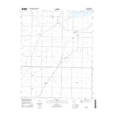
2014 Map of Cash
USGS Topo · Published 2014About this map
The Cache River and its intricate network of drainage channels define the agricultural landscape of Craighead County in this 2014 survey. The settlement of Cash serves as a central point, situated along the AR 18 Hwy S and N Front St. This region is characterized by small, dispersed communities including Egypt, Winesburg, Three Way, and Dryden, which are connected by a grid-like system of county roads. For genealogists, the Johnson Cem located south of Ar-226 provides a specific point of interest. The map meticulously documents the hydrological management of the area, featuring named waterways such as West Cache River Slough, Ditch Number 32, and Angle Ditch Lateral Number 4. Notable landmarks like Logan Bridge and the small settlement of Fisher further illustrate the rural connectivity of this Arkansas Delta territory.
Find a feature on this map
66 named features on this map. Tap any name to fly to it.
Don’t see what you’re looking for? This feature index may not catch every label — zoom into the map to look around manually.
Map Details
Editions of this 2014 Cash Map
This is the sole edition of this map. No revisions or reprints were ever made.
Other maps of this area

1935 · Sedgwick
USGS Topo · 1:62,500

1935 · Alicia
USGS Topo · 1:62,500

1935 · Tuckerman
USGS Topo · 1:62,500

1939 · Weiner
USGS Topo · 1:62,500

1953 · Memphis
USGS Topo · 1:250,000

1956 · Memphis
USGS Topo · 1:250,000

1959 · Weiner
USGS Topo · 1:62,500

1959 · Sedgwick
USGS Topo · 1:62,500

1960 · Weiner
USGS Topo · 1:62,500
1960 · Sedgwick
USGS Topo · 1:62,500