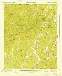
1947 Map of Cashes Valley
USGS Topo · Published 1948About this map
Cashes Valley is carved through the terrain of the Chattahoochee National Forest by Fightingtown Creek and its many branches. This 1946 field examination reveals a rural landscape defined by narrow hollows and steep gaps like Bush Head Gap and Augerhole Gap. The settlement pattern follows the water, with family-named landmarks like Jones Mill and Higdon Mill marking the local industry of the era. Education and faith are central to these mountain communities, evidenced by the scattered locations of Cashes Valley Sch, Harper Sch, and Salem Ch. Along the eastern edge, the Tennessee and North Carolina Railroad runs parallel to the Blue Ridge Highway, connecting the small settlements of Cherrylog and Santaluca to the broader regional economy.
Find a feature on this map
88 named features on this map. Tap any name to fly to it.
Don’t see what you’re looking for? This feature index may not catch every label — zoom into the map to look around manually.
Map Details
Editions of this 1947 Cashes Valley Map
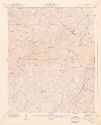
2 editions found
Other maps of this area

1886 · Dalton
USGS Topo · 1:125,000

1888 · Ellijay
USGS Topo · 1:125,000

1892 · Ellijay
USGS Topo · 1:125,000

1892 · Dalton
USGS Topo · 1:125,000

1897 · Dalton
USGS Topo · 1:125,000

1898 · Ellijay
USGS Topo · 1:125,000

1911 · Ellijay
USGS Topo · 1:125,000

1911 · Cohutta Mtn
USGS Topo · 1:62,500

1913 · Cohutta Mtn.
USGS Topo · 1:62,500

1914 · Talking Rock
USGS Topo · 1:62,500