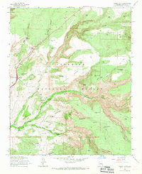
1965 Map of Casner Butte
USGS Topo · Published 1967About this map
Coconino National Forest dominates this mid-1960s survey, defined by the deep incisions of Wet Beaver Creek and Walker Creek. The map documents a specific era of land use where ranching and early outdoor recreation meet, evidenced by the proximity of Beaver Creek Ranch and Soda Spring Ranch to the Beaver Creek Campground. Local history is anchored at the Beaver Creek Ranger Sta and the river crossing at Lawrence Crossing. The terrain is characterized by massive landforms like White Mesa and Casner Butte, while the reliance on scarce water sources is seen in the dense network of tanks such as Watermelon Tank and John Henry Tank. For those tracing the geography of Yavapai County, the sheet preserves a network of primitive routes including the Blue Grade Road and Walker (Pack) Trail.
Find a feature on this map
62 named features on this map. Tap any name to fly to it.
Don’t see what you’re looking for? This feature index may not catch every label — zoom into the map to look around manually.
Map Details
Editions of this 1965 Casner Butte Map
3 editions found
Other maps of this area

1887 · Verde
USGS Topo · 1:250,000

1892 · Verde
USGS Topo · 1:250,000

1923 · Camp Verde
USGS Topo · 1:125,000

1932 · Camp Verde
USGS Topo · 1:125,000

1936 · Camp Verde
USGS Topo · 1:125,000

1954 · Holbrook
USGS Topo · 1:250,000

1957 · Holbrook
USGS Topo · 1:250,000

1958 · Holbrook
USGS Topo · 1:250,000

1960 · Holbrook
USGS Topo · 1:250,000
1965 · Munds Mountain
USGS Topo · 1:24,000