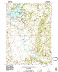
1990 Map of Cassa
USGS Topo · Published 1995About this map
Glendo Reservoir and the North Platte River anchor this topographic study of the Platte County landscape during the late twentieth century. The map details the infrastructure of Glendo Dam, including the Surge Tank Powerhouse, Shaft House, and various pumping stations that manage the river's flow through Bulls Bend. To the east, the Camp Guernsey State Military Reservation occupies a significant portion of the terrain, characterized by high points like Baldy Mountain and the steep walls of Wendover Canyon. Local settlement patterns are evidenced by the small community of Cassa and family-held lands such as Haushar Ranch and Herman Ranch. Of particular interest to historians is the route of the Emigrant Trail, which cuts across the western portion of the sheet, providing a spatial link between pioneer-era migration and modern features like the Burlington Northern railroad and Glendo State Park.
Find a feature on this map
37 named features on this map. Tap any name to fly to it.
Don’t see what you’re looking for? This feature index may not catch every label — zoom into the map to look around manually.
Map Details
Editions of this 1990 Cassa Map
This is the sole edition of this map. No revisions or reprints were ever made.
Other maps of this area

1896 · Hartville
USGS Topo · 1:125,000

1901 · Hartville
USGS Topo · 1:125,000

1949 · Cedar Top
USGS Topo · 1:24,000

1950 · Glendo
USGS Topo · 1:24,000

1950 · Cedar Top
USGS Topo · 1:24,000

1950 · Jewel Springs
USGS Topo · 1:24,000

1950 · Coleman Butte
USGS Topo · 1:24,000

1950 · Herman Ranch
USGS Topo · 1:24,000

1950 · Haushar Ranch
USGS Topo · 1:24,000

1950 · Guernsey Reservoir
USGS Topo · 1:24,000