
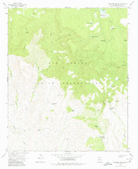
1966 Map of Cassadore Spring
USGS Topo · Published 1968About this map
The San Carlos Indian Reservation dominates this mid-1960s landscape, where a network of water sources supports cattle ranching in a remote section of Gila County. Water security is the primary driver of human activity here, marked by numerous developed springs and stock tanks like Sawmill Tank, Horse Pasture Tank, and the eponymous Cassadore Spring. The land is dotted with seasonal landmarks and livestock infrastructure, including Wild Beef Trap and the Hilltop Ranch in the northeast corner. Transport across the drainage basins of Rocky Creek and Sycamore Creek is limited to a sparse network of a Jeep Trail, emphasizing the area's isolation. Significant points of interest for local researchers include Bear Canyon Junction and the I K Bar Well, which represent the rare permanent improvements in this high-altitude terrain. The map's detailed contouring reveals the complex topography leading toward Indian Lookout and Lookout Hilltop.
Find a feature on this map
28 named features on this map. Tap any name to fly to it.
Don’t see what you’re looking for? This feature index may not catch every label — zoom into the map to look around manually.
Map Details
Editions of this 1966 Cassadore Spring Map
2 editions found
Other maps of this area

1922 · Chrysotile
USGS Topo · 1:125,000

1954 · Mesa
USGS Topo · 1:250,000

1957 · Mesa
USGS Topo · 1:250,000

1958 · Mesa
USGS Topo · 1:250,000

1960 · Mesa
USGS Topo · 1:250,000

1964 · Mesa
USGS Topo · 1:250,000

1965 · Sontag Mesa
USGS Topo · 1:24,000

1966 · Brushy Canyon
USGS Topo · 1:24,000

1966 · Natural Corral
USGS Topo · 1:24,000

1966 · Popcorn Canyon
USGS Topo · 1:24,000