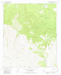
1966 Map of Cassadore Spring
USGS Topo · Published 1980About this map
The San Carlos Indian Reservation landscape is defined by a dense network of water features and livestock infrastructure as it appeared in the mid-1960s. High-elevation points like Indian Lookout and Lookout Hilltop overlook a complex drainage system where Alder Creek and Cassadore Creek carve through the terrain. The distribution of numerous water tanks, such as Sawmill Tank and Rose Garden Tank, alongside named springs like Keam Spring and Cold Spring, suggests a landscape heavily managed for cattle ranching. Traceable human activity is concentrated at Hilltop Ranch and the I K Bar Well, while specialized features like the Wild Beef Trap, Big Cedar Trap, and Geronimo Trap point toward traditional ranching methods used within the reservation. A network of primitive transport, marked as Jeep Trail, connects these remote outposts across the high ridges and deep canyons.
Find a feature on this map
31 named features on this map. Tap any name to fly to it.
Don’t see what you’re looking for? This feature index may not catch every label — zoom into the map to look around manually.
Map Details
Editions of this 1966 Cassadore Spring Map
2 editions found

Other maps of this area

1922 · Chrysotile
USGS Topo · 1:125,000

1954 · Mesa
USGS Topo · 1:250,000

1957 · Mesa
USGS Topo · 1:250,000

1958 · Mesa
USGS Topo · 1:250,000

1960 · Mesa
USGS Topo · 1:250,000

1964 · Mesa
USGS Topo · 1:250,000

1965 · Sontag Mesa
USGS Topo · 1:24,000

1966 · Brushy Canyon
USGS Topo · 1:24,000

1966 · Natural Corral
USGS Topo · 1:24,000

1966 · Popcorn Canyon
USGS Topo · 1:24,000