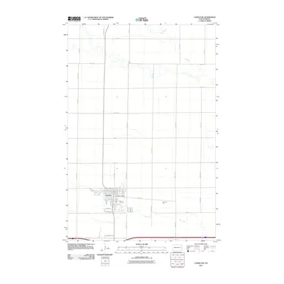
2011 Map of Casselton
USGS Topo · Published 2011About this map
Casselton serves as the focal point of this 2011 survey, showing the town's layout and its relationship to the surrounding agricultural landscape of Cass County. The town core is detailed with the Casselton Post Office and Saint Leo Cemetery as prominent local landmarks. The surrounding terrain is defined by the winding paths of the Rush River and Swan Creek, which snake across the grid of section roads like 154th Ave SE and 29th St SE. Industrial infrastructure is represented by the Dalrymple Spur railroad line and the Industrial Blvd corridor, illustrating the transportation network essential for moving goods in this Red River Valley region. The map captures the geometric precision of North Dakota's rural road system as it intersects with natural drainage patterns.
Find a feature on this map
27 named features on this map. Tap any name to fly to it.
Don’t see what you’re looking for? This feature index may not catch every label — zoom into the map to look around manually.
Map Details
Editions of this 2011 Casselton Map
This is the sole edition of this map. No revisions or reprints were ever made.
Other maps of this area

1895 · Casselton
USGS Topo · 1:125,000

1897 · Casselton
USGS Topo · 1:125,000

1952 · Grand Forks
USGS Topo · 1:250,000

1953 · Fargo
USGS Topo · 1:250,000

1956 · Fargo
USGS Topo · 1:250,000

1956 · Grand Forks
USGS Topo · 1:250,000

1961 · Durbin
USGS Topo · 1:24,000

1961 · Casselton
USGS Topo · 1:24,000
1961 · Casselton SE
USGS Topo · 1:24,000
1961 · Mapleton
USGS Topo · 1:24,000