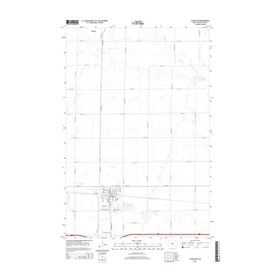
2014 Map of Casselton
USGS Topo · Published 2014About this map
The town of Casselton dominates the southern portion of this Red River Valley landscape, showing a structured grid of residential streets like Morningside Dr and Cottonwood Dr. Industrial activity is concentrated along the southern edge near Industrial Blvd and Governors Dr, while the local heritage is anchored by the Saint Leo Cem. To the north, the small settlement of Amenia sits along a north-south thoroughfare, surrounded by a vast agricultural grid defined by section-line roads.
Find a feature on this map
45 named features on this map. Tap any name to fly to it.
Don’t see what you’re looking for? This feature index may not catch every label — zoom into the map to look around manually.
Map Details
Editions of this 2014 Casselton Map
This is the sole edition of this map. No revisions or reprints were ever made.
Other maps of this area

1895 · Casselton
USGS Topo · 1:125,000

1897 · Casselton
USGS Topo · 1:125,000

1952 · Grand Forks
USGS Topo · 1:250,000

1953 · Fargo
USGS Topo · 1:250,000

1956 · Fargo
USGS Topo · 1:250,000

1956 · Grand Forks
USGS Topo · 1:250,000

1961 · Durbin
USGS Topo · 1:24,000

1961 · Casselton
USGS Topo · 1:24,000
1961 · Casselton SE
USGS Topo · 1:24,000
1961 · Mapleton
USGS Topo · 1:24,000