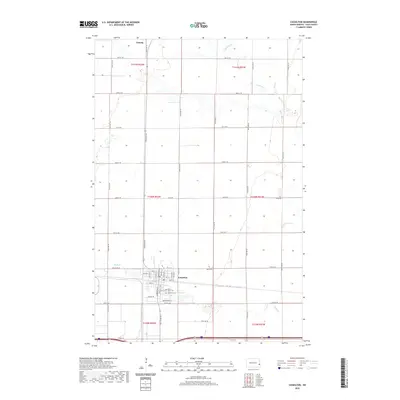
2020 Map of Casselton
USGS Topo · Published 2020About this map
Casselton serves as the primary hub of this eastern North Dakota agricultural landscape, positioned where the grid of sections and section-line roads meets the local rail-aligned street system. The map details a community structured around its transportation history, with Front St and Langer Ave N defining the central settlement. To the south, the local cemeteries, Leo's Cem and Casselton Cem, provide specific points of interest for genealogists and local historians tracking the area's residents. The surrounding township lines, including t140n r52w and t140n r51w, underscore the methodical land division characteristic of the Red River Valley. Further north, the small settlement of Amenia sits near the headwaters of the Rush River, which meanders across the northern sections, while Swan Creek drains the territory to the southwest near Old Co Rd 10.
Find a feature on this map
46 named features on this map. Tap any name to fly to it.
Don’t see what you’re looking for? This feature index may not catch every label — zoom into the map to look around manually.
Map Details
Editions of this 2020 Casselton Map
This is the sole edition of this map. No revisions or reprints were ever made.
Other maps of this area

1895 · Casselton
USGS Topo · 1:125,000

1897 · Casselton
USGS Topo · 1:125,000

1952 · Grand Forks
USGS Topo · 1:250,000

1953 · Fargo
USGS Topo · 1:250,000

1956 · Fargo
USGS Topo · 1:250,000

1956 · Grand Forks
USGS Topo · 1:250,000

1961 · Durbin
USGS Topo · 1:24,000

1961 · Casselton
USGS Topo · 1:24,000
1961 · Casselton SE
USGS Topo · 1:24,000
1961 · Mapleton
USGS Topo · 1:24,000