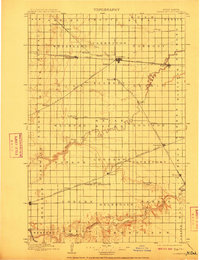
1897 Map of Casselton
USGS Topo · Published 1910About this map
Casselton serves as the central hub for a vast network of railroads crossing the Red River Valley in the late 19th century. The Northern Pacific R. R. (Main Line) bisects the region, connecting a string of grain-elevator settlements including Wheatland, Saxony, and Mapleton. To the south, the meandering Sheyenne River cuts through the township of Helendale, providing a sharp contrast to the rigid grid of section lines that define the agricultural landscape. Genealogists and local historians can trace the early footprints of numerous rural communities, some centered around small stations like Everest and Durbin, or post offices such as Chaffee P.O.. The map illustrates an era of rapid expansion as the Great Northern R. R. and several Northern Pacific branches, such as the Southwestern Branch through Leonard, established the transportation backbone of Cass County.
Find a feature on this map
76 named features on this map. Tap any name to fly to it.
Don’t see what you’re looking for? This feature index may not catch every label — zoom into the map to look around manually.
Map Details
Editions of this 1897 Casselton Map
3 editions found
Other maps of this area

1895 · Fargo
USGS Topo · 1:125,000

1895 · Casselton
USGS Topo · 1:125,000

1897 · Fargo
USGS Topo · 1:125,000

1897 · Tower
USGS Topo · 1:125,000

1897 · Casselton
USGS Topo · 1:125,000

1904 · Wahpeton
USGS Topo · 1:125,000

1907 · Wyndmere
USGS Topo · 1:125,000

1952 · Grand Forks
USGS Topo · 1:250,000

1953 · Fargo
USGS Topo · 1:250,000

1956 · Fargo
USGS Topo · 1:250,000