
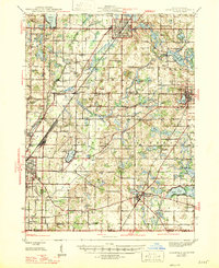
1947 Map of Cassopolis
USGS Topo · Published 1947About this map
Dowagiac and Cassopolis anchor this mid-century portrait of southwest Michigan, where the landscape is defined by a dense network of glacial lakes and small rural school districts. The 1940s environment is meticulously documented, showing the transition from the industrial activity in Niles to the agricultural reaches of Wayne and Jefferson townships. Genealogists will find significant value in the location of numerous country burying grounds such as Crawford Cem and Riverside Cem, alongside social centers like the Town Hall and the Infirmary near Stone Lake.
Find a feature on this map
94 named features on this map. Tap any name to fly to it.
Don’t see what you’re looking for? This feature index may not catch every label — zoom into the map to look around manually.
Map Details
Editions of this 1947 Cassopolis Map
2 editions found
Other maps of this area

1927 · Niles
USGS Topo · 1:62,500

1927 · Hartford
USGS Topo · 1:62,500

1927 · Benton Harbor
USGS Topo · 1:62,500

1930 · Benton Harbor
USGS Topo · 1:62,500

1930 · Niles
USGS Topo · 1:62,500

1931 · Hartford
USGS Topo · 1:62,500

1943 · Niles
USGS Topo · 1:62,500

1944 · Marcellus
USGS Topo · 1:62,500

1945 · Cassopolis
USGS Topo · 1:62,500

1946 · Marcellus
USGS Topo · 1:62,500