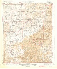
1944 Map of Cassville
USGS Topo · Published 1944About this map
Cassville and the surrounding Barry County landscape appear in this mid-century survey, characterized by a transition from the agricultural plains of Butterfield and Exeter to the more complex topography of the south. The Missouri and Arkansas RR serves as a vital corridor through the region, connecting rail stops like Pender Switch and the town of Seligman near the state line. A significant portion of the southeastern quadrant is dedicated to Roaring River State Park, where the C C C Camp and local infrastructure like the Roaring River School reflect the era's focus on conservation and public recreation.
Find a feature on this map
89 named features on this map. Tap any name to fly to it.
Don’t see what you’re looking for? This feature index may not catch every label — zoom into the map to look around manually.
Map Details
Editions of this 1944 Cassville Map
2 editions found

Other maps of this area

1899 · Fayetteville
USGS Topo · 1:125,000

1900 · Eureka Springs
USGS Topo · 1:125,000

1901 · Eureka Springs
USGS Topo · 1:125,000

1901 · Fayetteville
USGS Topo · 1:125,000

1904 · Fayetteville
USGS Topo · 1:125,000

1927 · Shell Knob
USGS Topo · 1:62,500

1937 · Cassville
USGS Topo · 1:48,000

1941 · Rocky Comfort
USGS Topo · 1:62,500

1942 · Aurora
USGS Topo · 1:62,500

1943 · Ritchey
USGS Topo · 1:62,500