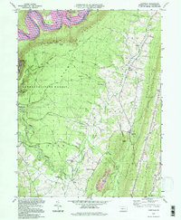
1994 Map of Cassville
USGS Topo · Published 1997About this map
Terrace Mountain and Sideling Hill define the steep ridges of Huntingdon County, framing the deep agricultural and residential corridors of Cassville Valley. At the heart of the region, the borough of Cassville serves as a central hub, surrounded by smaller historic hamlets including Todd, Calvin, and Colfax. The landscape is a mix of protected wilderness and local industry, with Rothrock State Forest and Trough Creek State Park occupying the high ground, while evidence of resource extraction appears in several Quarries and a Strip Mine near Rocky Ridge. Water shapes the terrain significantly, from the broad Raystown Lake and the Raystown Branch Juniata River to the intricate drainage of Great Trough Creek. Genealogists will find numerous family and community landmarks, including Sheridan Cem, Cornelius Cem, and the Trough Creek Valley Sch.
Find a feature on this map
53 named features on this map. Tap any name to fly to it.
Don’t see what you’re looking for? This feature index may not catch every label — zoom into the map to look around manually.
Map Details
Editions of this 1994 Cassville Map
This is the sole edition of this map. No revisions or reprints were ever made.
Other maps of this area

1901 · Huntingdon
USGS Topo · 1:62,500

1904 · Huntingdon
USGS Topo · 1:62,500

1922 · Mt Union
USGS Topo · 1:48,000

1924 · Mt. Union
USGS Topo · 1:62,500

1930 · Broad Top
USGS Topo · 1:62,500

1933 · Broad Top
USGS Topo · 1:62,500

1939 · Orbisonia
USGS Topo · 1:62,500

1940 · Orbisonia
USGS Topo · 1:62,500

1944 · Orbisonia
USGS Topo · 1:62,500

1944 · Mt. Union
USGS Topo · 1:62,500