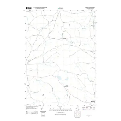
2013 Map of Cassville
USGS Topo · Published 2013About this map
Clayville and Cassville anchor this southern Oneida County landscape, where the headwaters of Sauquoit Cr and the Sangerfield River carve through a terrain of high ridges and hollows. The area is defined by a network of crossroads settlements and family-named corners such as McConnell Corners, Hubbard Corners, and Hobin Corners. Local landmarks like Tassel Hill and Hardscrabble Hill rise above the valleys, while the Sulphur Springs Golf Course and historic burial grounds like Eastman Cem and Budlong Cem reflect the long-standing community structure. Significant water bodies including Bailey Lake and Beaver Cr drain the rural spaces between the larger villages of Bridgewater and Mapledale, illustrating the transition from the upland farms to the creek-side hamlets that supported the region's development.
Find a feature on this map
85 named features on this map. Tap any name to fly to it.
Don’t see what you’re looking for? This feature index may not catch every label — zoom into the map to look around manually.
Map Details
Editions of this 2013 Cassville Map
This is the sole edition of this map. No revisions or reprints were ever made.
Other maps of this area

1895 · Oriskany
USGS Topo · 1:62,500

1898 · Utica
USGS Topo · 1:62,500

1898 · Oriskany
USGS Topo · 1:62,500

1900 · Utica
USGS Topo · 1:62,500

1907 · Winfield
USGS Topo · 1:62,500

1907 · Sangerfield
USGS Topo · 1:62,500

1943 · Utica East
USGS Topo · 1:24,000

1943 · Hubbardsville
USGS Topo · 1:24,000

1943 · Cassville
USGS Topo · 1:24,000

1943 · Unadilla Forks
USGS Topo · 1:24,000