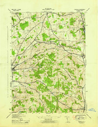
1945 Map of Cassville
USGS Topo · Published 1945About this map
Paris Station serves as a central point in this mid-century portrait of southern Oneida County, where the Delaware Lackawanna and Western RR cuts a path through the rolling hills of Marshall and Paris. The map reveals a dense network of local hamlets and crossroads, including McConnell Corners, Peck Corners, and Hubbard Corners, reflecting a deeply settled rural landscape during the war years. Education and community life are marked by the Sauquoit Valley Central School and smaller landmarks like the Tophet Schoolhouse.
Find a feature on this map
52 named features on this map. Tap any name to fly to it.
Don’t see what you’re looking for? This feature index may not catch every label — zoom into the map to look around manually.
Map Details
Editions of this 1945 Cassville Map
This is the sole edition of this map. No revisions or reprints were ever made.
Other maps of this area

1895 · Oriskany
USGS Topo · 1:62,500

1898 · Utica
USGS Topo · 1:62,500

1898 · Oriskany
USGS Topo · 1:62,500

1900 · Utica
USGS Topo · 1:62,500

1907 · Winfield
USGS Topo · 1:62,500

1907 · Sangerfield
USGS Topo · 1:62,500

1943 · Utica East
USGS Topo · 1:24,000

1943 · Hubbardsville
USGS Topo · 1:24,000

1943 · Cassville
USGS Topo · 1:24,000

1943 · Unadilla Forks
USGS Topo · 1:24,000