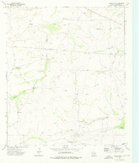
1973 Map of Castile Hill
USGS Topo · Published 1976About this map
Castile Hill rises above a landscape defined by the drainage systems of Castile Draw and Kimbell Draw in this 1970s topographical survey. The arid terrain in this part of Culberson County is marked by a network of isolated water sources essential for livestock and local habitation, including the Delaware Windmill, Little Castile Windmill, and Antelope Windmill. The presence of Sink Hole Flat indicates the distinctive karst topography of the region, where subterranean drainage creates surface depressions.
Find a feature on this map
16 named features on this map. Tap any name to fly to it.
Don’t see what you’re looking for? This feature index may not catch every label — zoom into the map to look around manually.
Map Details
Editions of this 1973 Castile Hill Map
This is the sole edition of this map. No revisions or reprints were ever made.
Other maps of this area

1954 · Van Horn
USGS Topo · 1:250,000

1958 · Van Horn
USGS Topo · 1:250,000

1973 · Seven L Peak
USGS Topo · 1:24,000

1973 · Owl Hills
USGS Topo · 1:24,000

1973 · Seven L Peak NE
USGS Topo · 1:24,000

1973 · Rustler Hills
USGS Topo · 1:24,000

1973 · Screw Bean Draw West
USGS Topo · 1:24,000

1973 · Delaware Spring
USGS Topo · 1:24,000
1973 · Outlaw Spring
USGS Topo · 1:24,000
1973 · Alligator Draw
USGS Topo · 1:24,000