
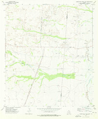
1973 Map of Screw Bean Draw West
USGS Topo · Published 1976About this map
The arid expanse of Culberson County is defined here by the intricate drainage systems of Screw Bean Draw and Kimbell Draw. Surveyed in the early 1970s, the landscape reveals a sparsely populated ranching environment where water sources like Toy Springs, Cottonwood Springs, and several unnamed Springs were essential for survival and livestock management. The presence of Collier Windmill and High Windmill further underscores the reliance on groundwater in this high-desert terrain. Industrial activity is represented by multiple Drill Holes and several Pipelines crossing the sheet, reflecting the region's mineral and energy exploration. Topographically, the Screw Bean Hills dominate the central-eastern portion of the map, characterized by complex contouring that indicates the weathered limestone and gypsum formations typical of the Delaware Basin's western edge.
Find a feature on this map
15 named features on this map. Tap any name to fly to it.
Don’t see what you’re looking for? This feature index may not catch every label — zoom into the map to look around manually.
Map Details
Editions of this 1973 Screw Bean Draw West Map
This is the sole edition of this map. No revisions or reprints were ever made.
Other maps of this area

1954 · Van Horn
USGS Topo · 1:250,000

1958 · Van Horn
USGS Topo · 1:250,000

1973 · Owl Hills
USGS Topo · 1:24,000

1973 · Seven L Peak NE
USGS Topo · 1:24,000

1973 · Rustler Hills
USGS Topo · 1:24,000
1973 · Derrick Draw
USGS Topo · 1:24,000
1973 · Screw Bean Draw NE
USGS Topo · 1:24,000
1973 · Castile Hill
USGS Topo · 1:24,000
1973 · Outlaw Spring
USGS Topo · 1:24,000
1973 · Screw Bean Draw East
USGS Topo · 1:24,000