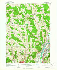
1961 Map of Castle Creek
USGS Topo · Published 1963About this map
The Chenango River valley anchors this early 1960s landscape, serving as a corridor for settlement and industry as it flows past Hillcrest and Port Dickinson. This survey captures a transitional period for the region, balancing traditional rural features like the Maple Grove Cem and Lilly Cem with mid-century infrastructure. The arrival of the Broome County Airport and the establishment of the County Technical Community College reflect the modernization of the Broome County area. Further south, the urban edge of Johnson City appears with dense street grids and landmarks such as the Ely Park Golf Course and Calvary Cemetery. Smaller hamlets like New Ireland and Castle Creek remain distinct among the higher terrain of Treadwell Hill and Smith Hill, connected by a winding network of country roads including Houdlum Road and Glen Castle West Chenango Road.
Find a feature on this map
78 named features on this map. Tap any name to fly to it.
Don’t see what you’re looking for? This feature index may not catch every label — zoom into the map to look around manually.
Map Details
Editions of this 1961 Castle Creek Map
This is the sole edition of this map. No revisions or reprints were ever made.
Other maps of this area

1901 · Apalachin
USGS Topo · 1:62,500

1903 · Harford
USGS Topo · 1:62,500

1904 · Binghamton
USGS Topo · 1:62,500

1904 · Greene
USGS Topo · 1:62,500

1904 · Apalachin
USGS Topo · 1:62,500

1906 · Catatonk
USGS Topo · 1:125,000

1934 · Castle Creek
USGS Topo · 1:24,000

1935 · Binghamton West
USGS Topo · 1:24,000

1935 · Chenango Forks
USGS Topo · 1:24,000

1937 · Binghamton East
USGS Topo · 1:24,000