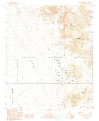
1990 Map of Castle Dome Peak
USGS Topo · Published 1990About this map
Kofa National Wildlife Refuge encompasses much of this arid landscape, where the jagged heights of the Castle Dome Mountains meet the sweeping Castle Dome Plain. The area is defined by a significant history of resource extraction, centered around the Castle Dome Mine and the nearby Hull Mine. These sites are marked by numerous mine shafts, adits, and prospects, alongside a Cem and a tailings pond that speak to the human presence in this desert environment. On the western edge, the boundary of the Yuma Proving Ground indicates the overlap of military and natural resource management. Water sources are critical but sparse, noted by scattered catchments like McPherson Tank, Ladder Tanks, and the secluded Doc Carter Spring located near the southeastern corner of the quadrangle.
Find a feature on this map
28 named features on this map. Tap any name to fly to it.
Don’t see what you’re looking for? This feature index may not catch every label — zoom into the map to look around manually.
Map Details
Editions of this 1990 Castle Dome Peak Map
This is the sole edition of this map. No revisions or reprints were ever made.
Other maps of this area

1929 · Laguna
USGS Topo · 1:62,500

1939 · Red Hill
USGS Topo · 1:62,500

1942 · Yuma
USGS Topo · 1:250,000

1942 · Blythe
USGS Topo · 1:250,000

1943 · Laguna
USGS Topo · 1:62,500

1954 · El Centro
USGS Topo · 1:250,000

1954 · Salton Sea
USGS Topo · 1:250,000

1954 · Red Hill
USGS Topo · 1:62,500

1955 · Salton Sea
USGS Topo · 1:250,000

1955 · El Centro
USGS Topo · 1:250,000