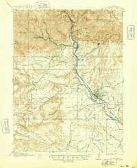
1916 Map of Castle Gate
USGS Topo · Published 1948About this map
Industrial activity and high-desert settlement define this 1914 survey of the Book Cliffs region. The Price River serves as the primary corridor for both water and transport, flanked by the Denver and Rio Grande Western Railroad. Along this route, the town of Helper and the industrial outpost at Castle Gate emerge as critical hubs for the local coal economy. The map documents numerous mining operations and company towns tucked into the narrow canyons, including Standardville, Storrs, and Kenilworth.
Find a feature on this map
60 named features on this map. Tap any name to fly to it.
Don’t see what you’re looking for? This feature index may not catch every label — zoom into the map to look around manually.
Map Details
Editions of this 1916 Castle Gate Map
2 editions found
Other maps of this area

1885 · Manti
USGS Topo · 1:250,000

1886 · Price River
USGS Topo · 1:250,000

1895 · Manti
USGS Topo · 1:250,000

1896 · Price River
USGS Topo · 1:250,000

1914 · Castle Gate
USGS Topo · 1:62,500

1915 · Wellington
USGS Topo · 1:62,500

1916 · Castle Gate
USGS Topo · 1:62,500

1923 · Scofield
USGS Topo · 1:62,500

1923 · Hiawatha
USGS Topo · 1:62,500

1925 · Scofield
USGS Topo · 1:62,500