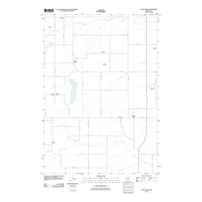
2010 Map of Castle Rock
USGS Topo · Published 2010About this map
Eureka Center and Castle Rock anchor this agricultural landscape in southern Dakota County, where the topography is defined by the winding course of the Vermillion River and Chub Creek. The map reveals a high density of rural burial grounds, including the Greenwood Cemetery in the north and the Solar Lutheran Cemetery further south, providing essential data points for local genealogists. The presence of several private landing strips, such as Curry Airport, Le Nores Airport, and Nielsens Airport, suggests a legacy of general aviation integrated with the area's farming operations. The township grid is well-established by a network of numbered and named roads like Hamburg Ave and Cedar Ave, which navigate the terrain around Chub Lake and its associated wetlands. This survey captures the transition of traditional rural townships as they maintain their agrarian character while serving as a satellite to the expanding northern suburbs.
Find a feature on this map
50 named features on this map. Tap any name to fly to it.
Don’t see what you’re looking for? This feature index may not catch every label — zoom into the map to look around manually.
Map Details
Editions of this 2010 Castle Rock Map
This is the sole edition of this map. No revisions or reprints were ever made.
Other maps of this area

1953 · Saint Paul
USGS Topo · 1:250,000

1957 · Farmington
USGS Topo · 1:62,500

1957 · Prior Lake
USGS Topo · 1:62,500

1959 · Saint Paul
USGS Topo · 1:250,000

1960 · Northfield
USGS Topo · 1:24,000

1960 · Dennison
USGS Topo · 1:24,000

1960 · Little Chicago
USGS Topo · 1:24,000
1974 · Coates
USGS Topo · 1:24,000
1974 · New Market
USGS Topo · 1:24,000
1974 · Randolph
USGS Topo · 1:24,000