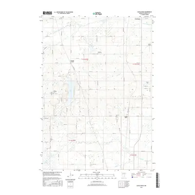
2016 Map of Castle Rock
USGS Topo · Published 2016About this map
Eureka Center and the rural crossroads of Castle Rock anchor this survey of southern Dakota County, where a grid of township roads overlays a landscape defined by glacial hydrology. The terrain is marked by the presence of Chub Lake and a winding network of waterways including the Vermillion River and Chub Cr. These water features dictated the early settlement patterns and the placement of several local cemeteries, such as the Highview Christiana Cem and Farmington Lutheran Cem, which remain as essential touchstones for local genealogical research. Small-scale aviation is represented by Nielsen's Airport and Jennrich Field in the eastern half of the quadrangle. The map captures the agricultural character of the region as it transitioned into the early 21st century, maintaining its traditional center points while serving as a periphery for larger neighboring communities.
Find a feature on this map
69 named features on this map. Tap any name to fly to it.
Don’t see what you’re looking for? This feature index may not catch every label — zoom into the map to look around manually.
Map Details
Editions of this 2016 Castle Rock Map
This is the sole edition of this map. No revisions or reprints were ever made.
Other maps of this area

1953 · Saint Paul
USGS Topo · 1:250,000

1957 · Farmington
USGS Topo · 1:62,500

1957 · Prior Lake
USGS Topo · 1:62,500

1959 · Saint Paul
USGS Topo · 1:250,000

1960 · Northfield
USGS Topo · 1:24,000

1960 · Dennison
USGS Topo · 1:24,000

1960 · Little Chicago
USGS Topo · 1:24,000
1974 · Coates
USGS Topo · 1:24,000
1974 · New Market
USGS Topo · 1:24,000
1974 · Randolph
USGS Topo · 1:24,000