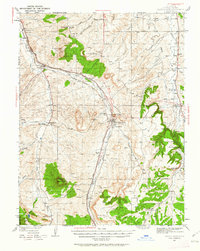
1940 Map of Castle Rock
USGS Topo · Published 1962About this map
The confluence of rail and ranching defines this mid-century landscape in Douglas County, centered on the growing community of Castle Rock. Two major rail lines, the Denver and Rio Grande Western RR and the Atchison Topeka and Santa Fe RR, parallel the course of Plum Creek, serving local shipping points at Sedalia and Louviers Sta. The map documents a period when rural schoolhouses like Gann Sch and Oakland Sch still served localized agricultural districts, and social life centered on landmarks like the Pikes Peak Grange Hall.
Find a feature on this map
62 named features on this map. Tap any name to fly to it.
Don’t see what you’re looking for? This feature index may not catch every label — zoom into the map to look around manually.
Map Details
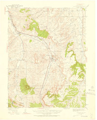
Editions of this 1940 Castle Rock Map
3 editions found
Other maps of this area

1890 · East Denver
USGS Topo · 1:125,000

1893 · Platte Canyon
USGS Topo · 1:125,000

1894 · Castle Rock
USGS Topo · 1:125,000

1899 · West Denver
USGS Topo · 1:125,000

1913 · Castle Rock
USGS Topo · 1:125,000

1935 · East Denver Nos. 3 and 4
USGS Topo · 1:48,000

1939 · Elizabeth
USGS Topo · 1:62,500

1940 · Piney Creek
USGS Topo · 1:24,000

1940 · Elbert
USGS Topo · 1:62,500
1940 · Castle Rock
USGS Topo · 1:62,500