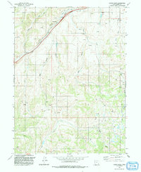
1991 Map of Castle Rock
USGS Topo · Published 1991About this map
The settlement of Castle Rock anchors this northeastern Utah landscape, situated at the confluence of several prominent drainages. The area is defined by a series of deep canyons, including Brown Canyon, Stag Canyon, and Robinson Canyon, which channel water toward the primary corridor of Echo Creek. This topographical pattern facilitated early transportation and ranching, evidenced by the numerous Spring and Springs labels and isolated Corral sites scattered throughout the terrain.
Find a feature on this map
17 named features on this map. Tap any name to fly to it.
Don’t see what you’re looking for? This feature index may not catch every label — zoom into the map to look around manually.
Map Details
Editions of this 1991 Castle Rock Map
This is the sole edition of this map. No revisions or reprints were ever made.
Other maps of this area

1885 · Salt Lake
USGS Topo · 1:250,000

1900 · Coalville
USGS Topo · 1:125,000

1903 · Coalville
USGS Topo · 1:125,000

1954 · Salt Lake City
USGS Topo · 1:250,000

1954 · Ogden
USGS Topo · 1:250,000

1958 · Ogden
USGS Topo · 1:250,000

1958 · Salt Lake City
USGS Topo · 1:250,000

1960 · Ogden
USGS Topo · 1:250,000

1960 · Salt Lake City
USGS Topo · 1:250,000

1964 · Francis Canyon
USGS Topo · 1:24,000